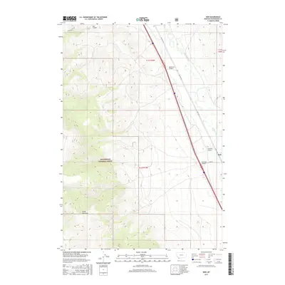
2017 Map of Kidd
USGS Topo · Published 2017About this map
The settlement of Kidd sits at the junction of Kidd Ln and Red Rock Rd, serving as a focal point for this high-elevation landscape in Beaverhead County. The terrain is defined by the eastern slopes of the Tenday Mountains and the canyons that carve through the local topography, including McKenzie Canyon, Limekiln Canyon, and McKnight Canyon. To the west, the protected lands of the Beaverhead National Forest dominate the mountain slopes, while the Red Rock River winds through the valley floor to the east. Water features like Bell Canyon and Kelmbeck Cr highlight the drainage patterns typical of this part of Montana, where ranching and forest management intersect. The grid of township and range lines, such as t12s r10w, provides a framework for the vast, sparsely populated areas between these mountain ridges.
Find a feature on this map
15 named features on this map. Tap any name to fly to it.
Don’t see what you’re looking for? This feature index may not catch every label — zoom into the map to look around manually.
Map Details
Editions of this 2017 Kidd Map
This is the sole edition of this map. No revisions or reprints were ever made.
Other maps of this area

1955 · Dubois
USGS Topo · 1:250,000

1958 · Dubois
USGS Topo · 1:250,000
1965 · Garfield Canyon
USGS Topo · 1:24,000

1965 · Kidd
USGS Topo · 1:24,000
1965 · Monument Hill
USGS Topo · 1:24,000

1965 · Briggs Ranch
USGS Topo · 1:24,000
1965 · Red Rock
USGS Topo · 1:24,000

1965 · Graphite Mountain
USGS Topo · 1:24,000

1965 · Deer Canyon
USGS Topo · 1:24,000

1965 · Dixon Mountain
USGS Topo · 1:24,000