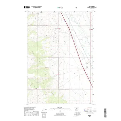
2020 Map of Kidd
USGS Topo · Published 2020About this map
The Tendoy Mountains dominate the western horizon of this Beaverhead County landscape, where the high-altitude terrain transitions into the valley of the Red Rock River. This area is characterized by the stark contrast between the protected timberlands of the Beaverhead National Forest and the corridor of transport and settlement along the river. The small community of Kidd serves as a focal point near the mouth of McKnight Canyon, positioned where the valley floor meets the rising slopes of the range. Numerous drainage systems, including Bell Canyon, McKenzie Canyon, and Limekiln Canyon, cut through the eastern faces of the mountains, illustrating the complex drainage patterns that feed into the larger river basin. The road network, including Red Rock Rd and Kidd Ln, follows the natural contours of the valley, tracing a path that has historically connected these isolated ranching and mountain reaches.
Find a feature on this map
16 named features on this map. Tap any name to fly to it.
Don’t see what you’re looking for? This feature index may not catch every label — zoom into the map to look around manually.
Map Details
Editions of this 2020 Kidd Map
This is the sole edition of this map. No revisions or reprints were ever made.
Other maps of this area

1955 · Dubois
USGS Topo · 1:250,000

1958 · Dubois
USGS Topo · 1:250,000
1965 · Garfield Canyon
USGS Topo · 1:24,000

1965 · Kidd
USGS Topo · 1:24,000
1965 · Monument Hill
USGS Topo · 1:24,000

1965 · Briggs Ranch
USGS Topo · 1:24,000
1965 · Red Rock
USGS Topo · 1:24,000

1965 · Graphite Mountain
USGS Topo · 1:24,000

1965 · Deer Canyon
USGS Topo · 1:24,000

1965 · Dixon Mountain
USGS Topo · 1:24,000