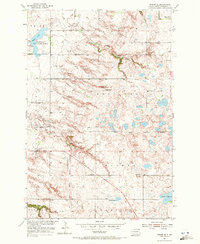
1954 Map of Kidder SE
USGS Topo · Published 1971About this map
The Old Fort Sisseton Military Reservation Boundary cuts across this prairie landscape in Marshall County, marking the historical footprint of the 19th-century frontier outpost. During this mid-century survey, the region shows a transition in local education, with School No 1 and School No 2 reflecting a changing rural population even as another School No 1 remained active. To the northwest, the White Lake State Game Refuge encompasses White Lake, while the drainages of Wild Rice Creek and Crow Creek define the local topography. The map illustrates a strictly agricultural and conservation-focused era, with scattered Gravel Pits and named water features like Black Slough and Stink Slough punctuating the township grids of Norland, Wismer, and Victor.
Find a feature on this map
23 named features on this map. Tap any name to fly to it.
Don’t see what you’re looking for? This feature index may not catch every label — zoom into the map to look around manually.
Map Details
Editions of this 1954 Kidder SE Map
3 editions found
Other maps of this area

1953 · Britton East
USGS Topo · 1:24,000

1953 · Kidder
USGS Topo · 1:24,000

1953 · Milbank
USGS Topo · 1:250,000

1954 · Kidder SE
USGS Topo · 1:24,000

1956 · Havana
USGS Topo · 1:24,000

1958 · Milbank
USGS Topo · 1:250,000

1958 · Britton 4 NW
USGS Topo · 1:24,000

1958 · Hillhead
USGS Topo · 1:24,000

1958 · Marlow
USGS Topo · 1:24,000

1970 · Britton 4 NE
USGS Topo · 1:24,000