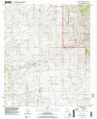
1996 Map of Kielberg Canyon
USGS Topo · Published 2003About this map
The Galiuro Mountains dominate this high-desert landscape where the borders of Graham, Pinal, and Pima counties converge. This 1990s-era survey captures a land defined by water management in a demanding environment, as evidenced by the distribution of livestock-supporting features like YLE Ranch and scattered water sources such as Border Well, Peters Well, and Torro Well. The topography is etched by deep drainages, including the prominent Kielberg Canyon and Charlie Kielberg Canyon, which feed toward the San Pedro River valley in the southwest corner.
Find a feature on this map
27 named features on this map. Tap any name to fly to it.
Don’t see what you’re looking for? This feature index may not catch every label — zoom into the map to look around manually.
Map Details
Editions of this 1996 Kielberg Canyon Map
This is the sole edition of this map. No revisions or reprints were ever made.
Other maps of this area

1904 · Tucson
USGS Topo · 1:125,000

1905 · Tucson
USGS Topo · 1:125,000

1911 · Winkelman
USGS Topo · 1:125,000

1913 · Winkelman
USGS Topo · 1:125,000

1938 · Galiuro Mts
USGS Topo · 1:48,000

1943 · Galiuro Mts
USGS Topo · 1:62,500

1945 · Redington
USGS Topo · 1:62,500

1948 · Clark Ranch
USGS Topo · 1:24,000

1948 · Mammoth
USGS Topo · 1:62,500

1948 · Peppersauce Wash
USGS Topo · 1:24,000