
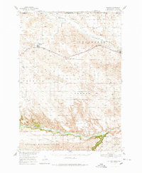
1950 Map of Kilgore
USGS Topo · Published 1952About this map
The Chicago and North Western railroad bisects the high plains of northern Nebraska in this 1950 survey, connecting the small settlements of Kilgore and Crookston. The landscape is defined by the sharp transition from the rolling prairie in the north, where Minnechaduza Creek flows toward the Rosebud Indian Reservation, to the deep incisions of the Niobrara River valley in the south. This southern reach is characterized by the Nebraska National Forest and a series of steep canyons, including a prominent Flowing Well and the Anderson Bridge crossing.
Find a feature on this map
31 named features on this map. Tap any name to fly to it.
Don’t see what you’re looking for? This feature index may not catch every label — zoom into the map to look around manually.
Map Details
Editions of this 1950 Kilgore Map
2 editions found
Other maps of this area

1950 · Simeon
USGS Topo · 1:62,500

1950 · Powderhorn Valley
USGS Topo · 1:62,500

1950 · Kennedy
USGS Topo · 1:62,500

1950 · Valentine
USGS Topo · 1:62,500

1950 · Cody
USGS Topo · 1:62,500

1955 · Martin
USGS Topo · 1:250,000

1957 · Valentine
USGS Topo · 1:250,000

1958 · Martin
USGS Topo · 1:250,000

1959 · Valentine
USGS Topo · 1:250,000

1969 · Spring Creek
USGS Topo · 1:24,000