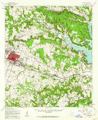
1958 Map of Killeen
USGS Topo · Published 1962About this map
The Fort Hood Military Reservation dominates the northern half of this Central Texas landscape, reflecting the massive military expansion that transformed the region during the mid-20th century. While the city of Killeen shows significant growth at the base's doorstep, the surrounding rural heritage remains visible through numerous family landmarks and community centers. Historically important sites like the Killeen City Cem, Pleasant Hill Cem, and Keys Valley Ch anchor the local genealogy of Bell County. The landscape is bisected by the Gulf Colorado and Santa Fe railroad, which parallels Nolan Creek and connects the established settlements of Nolanville and Walker Village. To the east, the rising waters of the Belton Reservoir mark a shift in the local geography, inundating the valleys near the Owl Creek Mountains and providing a stark contrast to the high points of Dana Peak and Sugar Loaf Mtn.
Find a feature on this map
47 named features on this map. Tap any name to fly to it.
Don’t see what you’re looking for? This feature index may not catch every label — zoom into the map to look around manually.
Map Details
Editions of this 1958 Killeen Map
This is the sole edition of this map. No revisions or reprints were ever made.
Other maps of this area

1885 · Taylor
USGS Topo · 1:125,000

1887 · Taylor
USGS Topo · 1:125,000

1892 · Temple
USGS Topo · 1:125,000

1893 · Georgetown
USGS Topo · 1:125,000

1894 · Gatesville
USGS Topo · 1:125,000

1894 · Taylor
USGS Topo · 1:125,000

1924 · Gatesville 4-d
USGS Topo · 1:48,000

1924 · Gatesville 4-a
USGS Topo · 1:48,000

1924 · Temple 2-C
USGS Topo · 1:48,000

1924 · Temple 3-C
USGS Topo · 1:48,000