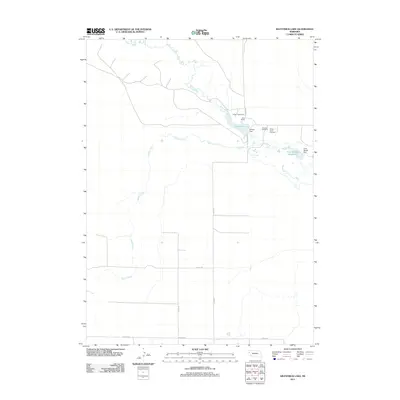
2011 Map of Kilpatrick Lake
USGS Topo · Published 2011About this map
Snake Creek and Spring Creek wind through this corner of the Nebraska panhandle, defining a landscape of ranching and water management. The map details the vital role of irrigation and storage in this arid region, highlighted by Kilpatrick Lake and the Cook Middle Reservoir, both maintained by significant structures like Elmore Dam and Cook Middle Dam. Local heritage is anchored by family-named holdings such as Snake Creek Ranch and Cook Ranch, which have likely shaped the area for generations.
Find a feature on this map
16 named features on this map. Tap any name to fly to it.
Don’t see what you’re looking for? This feature index may not catch every label — zoom into the map to look around manually.
Map Details
Editions of this 2011 Kilpatrick Lake Map
This is the sole edition of this map. No revisions or reprints were ever made.
Other maps of this area

1898 · Camp Clarke
USGS Topo · 1:125,000

1948 · Hemingford 4 SW
USGS Topo · 1:24,000

1948 · Hemingford 4 NW
USGS Topo · 1:24,000

1951 · Kilpatrick Lake
USGS Topo · 1:62,500

1954 · Scottsbluff
USGS Topo · 1:250,000

1955 · Alliance
USGS Topo · 1:250,000

1957 · Alliance
USGS Topo · 1:250,000

1958 · Alliance
USGS Topo · 1:250,000

1958 · Scottsbluff
USGS Topo · 1:250,000
1965 · Bayard NE
USGS Topo · 1:24,000