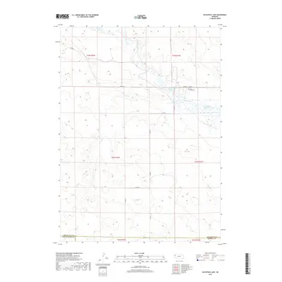
2017 Map of Kilpatrick Lake
USGS Topo · Published 2017About this map
Kilpatrick Lake and the drainage of Snake Cr define this landscape in the western Nebraska panhandle, located along the borders of Scotts Bluff, Box Butte, and Morrill Counties. The area is characterized by its agricultural section lines and water management features, including the Cook Middle Reservoir and numerous small water bodies fed by Spring Cr. Local history is anchored by the presence of family-named landmarks such as Severson Cem and the Snake Creek Cem, which sit north of Rock Rd. The terrain is navigated by a network of rural roads such as Perkins Rd and Valley Rd, illustrating the persistence of early land division systems in this plains region. This survey captures the rural infrastructure and hydraulic patterns essential to the ranching and farming operations of the High Plains.
Find a feature on this map
21 named features on this map. Tap any name to fly to it.
Don’t see what you’re looking for? This feature index may not catch every label — zoom into the map to look around manually.
Map Details
Editions of this 2017 Kilpatrick Lake Map
This is the sole edition of this map. No revisions or reprints were ever made.
Other maps of this area

1898 · Camp Clarke
USGS Topo · 1:125,000

1948 · Hemingford 4 SW
USGS Topo · 1:24,000

1948 · Hemingford 4 NW
USGS Topo · 1:24,000

1951 · Kilpatrick Lake
USGS Topo · 1:62,500

1954 · Scottsbluff
USGS Topo · 1:250,000

1955 · Alliance
USGS Topo · 1:250,000

1957 · Alliance
USGS Topo · 1:250,000

1958 · Alliance
USGS Topo · 1:250,000

1958 · Scottsbluff
USGS Topo · 1:250,000
1965 · Bayard NE
USGS Topo · 1:24,000