
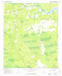
1943 Map of Kilsock Bay
USGS Topo · Published 1962About this map
The low-lying wetlands of Georgetown County are dominated by the extensive Little Kilsock Bay and Big Kilsock Bay, which illustrate the distinct "Carolina Bay" elliptical depressions characteristic of this coastal plain. In the early 1940s, this landscape was a network of tidal waters and swampy interiors, with the Sampit River and Wadmacon Creek framing the region's geography. Settlement patterns appear concentrated on slightly higher ground, with small communities such as Sampit, Cumberland, and New Hope linked by unimproved roads. The presence of St Paul Ch and Friendship Ch indicates the established social hubs for rural residents. Industrial or forestry observation is marked by a Lookout Tower overlooking Summons Swamp, while terrain features like Bron Neck and Kilsock Island emerge from the surrounding marsh, providing a clear look at the area's complex drainage system before mid-century development.
Find a feature on this map
20 named features on this map. Tap any name to fly to it.
Don’t see what you’re looking for? This feature index may not catch every label — zoom into the map to look around manually.
Map Details
Editions of this 1943 Kilsock Bay Map
2 editions found
Other maps of this area

1942 · Cedar Creek
USGS Topo · 1:24,000

1942 · Honey Hill
USGS Topo · 1:24,000

1943 · Olin
USGS Topo · 1:31,680

1943 · Andrews
USGS Topo · 1:24,000

1943 · Santee
USGS Topo · 1:24,000

1943 · Georgetown North
USGS Topo · 1:24,000

1943 · Minim Island
USGS Topo · 1:24,000

1943 · Georgetown South
USGS Topo · 1:24,000

1947 · Georgetown South
USGS Topo · 1:24,000

1949 · Georgetown
USGS Topo · 1:250,000