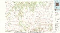
1982 Map of Kim
USGS Topo · Published 1983About this map
The Purgatoire River carves a deep path through the high plains of southern Colorado, defining the dramatic topography of Purgatoire Canyon and Chacuaco Canyon. This early 1980s survey captures a landscape where the vast Mesa de Maya and Black Mesa dominate the horizon near the New Mexico and Oklahoma borders. The map records the trace of the historic Santa Fe Trail cutting across the central plains, providing a significant navigational marker for regional history. Small ranching settlements like Kim, Villegreen, and Tobe anchor the rural infrastructure, while the Colorado and Southern railroad runs through the southwestern corner near Branson. The survey also highlights numerous drainages such as Carrizo Creek and Mustang Creek, which are critical to the water-scarce environment of Las Animas County and Baca County.
Find a feature on this map
47 named features on this map. Tap any name to fly to it.
Don’t see what you’re looking for? This feature index may not catch every label — zoom into the map to look around manually.
Map Details
Editions of this 1982 Kim Map
2 editions found
Other maps of this area

1891 · Higbee
USGS Topo · 1:125,000

1891 · Timpas
USGS Topo · 1:125,000

1891 · Apishapa
USGS Topo · 1:125,000

1891 · Springfield
USGS Topo · 1:125,000

1891 · Mesa De Maya
USGS Topo · 1:125,000

1892 · Two Butte
USGS Topo · 1:125,000

1892 · Elmoro
USGS Topo · 1:125,000

1892 · Mt Carrizo
USGS Topo · 1:125,000

1893 · Higbee
USGS Topo · 1:125,000

1893 · Apishapa
USGS Topo · 1:125,000