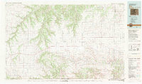
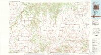
1982 Map of Kim
USGS Topo · Published 1983About this map
The Santa Fe Trail cuts across this high plains landscape at the intersection of Colorado, New Mexico, and Oklahoma. This early 1980s survey captures a vast ranching and canyon region dominated by the massive Mesa de Maya and the deep incision of the Purgatoire River in the northwest. Small, isolated ranching communities like Kim, Villegreen, and Utleyville serve as the primary human anchors in an area defined by its topographic extremes, from the flat reaches of Middle Mesa to the complex drainage systems of Chacuaco Creek and Carrizo Creek.
Find a feature on this map
44 named features on this map. Tap any name to fly to it.
Don’t see what you’re looking for? This feature index may not catch every label — zoom into the map to look around manually.
Map Details
Editions of this 1982 Kim Map
2 editions found
Other maps of this area

1891 · Higbee
USGS Topo · 1:125,000

1891 · Timpas
USGS Topo · 1:125,000

1891 · Apishapa
USGS Topo · 1:125,000

1891 · Springfield
USGS Topo · 1:125,000

1891 · Mesa De Maya
USGS Topo · 1:125,000

1892 · Two Butte
USGS Topo · 1:125,000

1892 · Elmoro
USGS Topo · 1:125,000

1892 · Mt Carrizo
USGS Topo · 1:125,000

1893 · Higbee
USGS Topo · 1:125,000

1893 · Apishapa
USGS Topo · 1:125,000