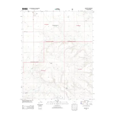
2013 Map of Kim South
USGS Topo · Published 2013About this map
The high plains of Las Animas County meet the rugged geography of the Comanche National Grassland in this 2013 survey. The settlement of Kim serves as the primary local hub, located near the intersection of several county roads and the major transit artery of US Hwy 160. Local history is grounded at the Kim Cem just northwest of town, while the surrounding landscape is defined by the dramatic relief of Tecolate Mesa and the drainage systems of Pintada Cr and Tecolate Cr. This map illustrates the intersection of public grazing lands and private ranching interests, where seasonal watercourses like Saltillo Cr and W Carrizo Cr carve through features like Baldy Canyon and Couchman Draw. The vast, open character of the southeastern Colorado territory is preserved here, showing the enduring spatial organization of the Public Land Survey System.
Find a feature on this map
20 named features on this map. Tap any name to fly to it.
Don’t see what you’re looking for? This feature index may not catch every label — zoom into the map to look around manually.
Map Details
Editions of this 2013 Kim South Map
This is the sole edition of this map. No revisions or reprints were ever made.
Other maps of this area

1892 · Mt Carrizo
USGS Topo · 1:125,000

1955 · La Junta
USGS Topo · 1:250,000

1958 · La Junta
USGS Topo · 1:250,000

1968 · La Junta
USGS Topo · 1:250,000
1978 · Dalerose Mesa
USGS Topo · 1:24,000

1978 · Pintada Creek
USGS Topo · 1:24,000
1978 · Furnish Canyon West
USGS Topo · 1:24,000
1978 · Cherry Canyon
USGS Topo · 1:24,000
1978 · Jesus Canyon
USGS Topo · 1:24,000
1978 · Dennis Canyon
USGS Topo · 1:24,000