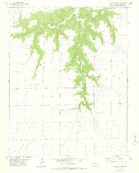
1978 Map of Cherry Canyon
USGS Topo · Published 1978About this map
Granada Santa Fe Trail cuts across the southern portion of this Las Animas County landscape, marking a historic corridor of movement through the high plains. The topography is defined by the deep incision of Cherry Canyon and its tributaries, including Snake Canyon and Smith Canyon, which drain into the broader Plum Valley to the south. The rugged drainage systems are punctuated by localized water sources such as Spring and Soldier Canyon, essential landmarks in an otherwise arid rangeland. Unlike many Western maps of this era that show significant ranching infrastructure, this sheet reveals a sparse settlement pattern, with only an occasional Well or isolated spring supporting the livestock operations that dominate the plateau. The land remains largely open, partitioned by section lines that guide the remote roads connecting the canyons to the valley floor.
Find a feature on this map
14 named features on this map. Tap any name to fly to it.
Don’t see what you’re looking for? This feature index may not catch every label — zoom into the map to look around manually.
Map Details
Editions of this 1978 Cherry Canyon Map
This is the sole edition of this map. No revisions or reprints were ever made.
Other maps of this area

1891 · Mesa De Maya
USGS Topo · 1:125,000

1892 · Mt Carrizo
USGS Topo · 1:125,000

1893 · Mesa de Maya
USGS Topo · 1:125,000

1955 · La Junta
USGS Topo · 1:250,000

1958 · La Junta
USGS Topo · 1:250,000

1968 · La Junta
USGS Topo · 1:250,000

1972 · Plum Canyon
USGS Topo · 1:24,000

1972 · Tobe
USGS Topo · 1:24,000
1972 · Villegreen
USGS Topo · 1:24,000
1978 · Dalerose Mesa
USGS Topo · 1:24,000