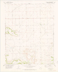
1978 Map of Dalerose Mesa
USGS Topo · Published 1978About this map
Fallas Mesa and Dalerose Mesa rise prominently above the surrounding plains of Las Animas County, where the topography transitions into the massive Mesa De Maya to the south. This late 1970s survey documents a sparse ranching and grazing landscape where water sources and elevation dictates the pattern of human activity. Settled life is represented by the remote Windswept locale and the White School, an essential community hub in this sprawling territory.
Find a feature on this map
21 named features on this map. Tap any name to fly to it.
Don’t see what you’re looking for? This feature index may not catch every label — zoom into the map to look around manually.
Map Details
Editions of this 1978 Dalerose Mesa Map
This is the sole edition of this map. No revisions or reprints were ever made.
Other maps of this area

1891 · Mesa De Maya
USGS Topo · 1:125,000

1892 · Mt Carrizo
USGS Topo · 1:125,000

1893 · Mesa de Maya
USGS Topo · 1:125,000

1955 · La Junta
USGS Topo · 1:250,000

1958 · La Junta
USGS Topo · 1:250,000

1968 · La Junta
USGS Topo · 1:250,000
1972 · Cobert Mesa North
USGS Topo · 1:24,000

1972 · Tobe
USGS Topo · 1:24,000
1972 · Villegreen
USGS Topo · 1:24,000
1978 · Cherry Canyon
USGS Topo · 1:24,000