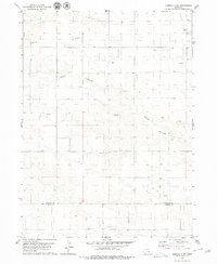
1979 Map of Kimball 2 NE
USGS Topo · Published 1979About this map
The high plains along the Banner Co Kimball Co border reflect an era of intensive energy extraction in the late 1970s. The landscape is defined by a sparse but systematic industrial network, where numerous Oil Wells and a central Oil Field are connected by unimproved roads across the rolling terrain. Outside of these petroleum operations, the topography is carved by the significant drainage of Rocky Hollow, which winds across the quadrangle. Other human footprints include a prominent Radio Tower in the northeast and a point labeled Badger, while scattered Gravel Pits suggest local material sourcing for the road network. This survey captures a moment when the rural economy of Western Nebraska was deeply integrated with the subsurface mineral wealth of the Denver-Julesburg Basin.
Find a feature on this map
9 named features on this map. Tap any name to fly to it.
Don’t see what you’re looking for? This feature index may not catch every label — zoom into the map to look around manually.
Map Details
Editions of this 1979 Kimball 2 NE Map
2 editions found
Other maps of this area

1898 · Scotts Bluff
USGS Topo · 1:125,000

1954 · Scottsbluff
USGS Topo · 1:250,000

1958 · Scottsbluff
USGS Topo · 1:250,000

1973 · Kimball 2 NE
USGS Topo · 1:24,000

1973 · Kimball 2 SE
USGS Topo · 1:24,000
1973 · Kimball 2 SW
USGS Topo · 1:24,000

1973 · Scotts Bluff 4 SW
USGS Topo · 1:24,000

1973 · Scotts Bluff 3 SE
USGS Topo · 1:24,000
1973 · Kimball 2 NW
USGS Topo · 1:24,000

1973 · Kimball 1 NW
USGS Topo · 1:24,000