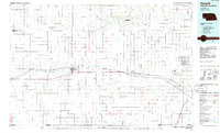
1985 Map of Kimball
USGS Topo · Published 1985About this map
Lodgepole Creek defines the east-west corridor of this High Plains landscape, serving as the historical backbone for both the Union Pacific railroad and the string of small towns that grew alongside it. The mid-1980s terrain is characterized by broad drainage features like Rocky Hollow and Sand Draw, with the industrial footprint of the region clearly visible through numerous Oil Field designations. Settlement patterns are concentrated in towns such as Bushnell, Dix, and Potter, while the presence of the Ammunition Depot (Abandoned) near Brownson speaks to a mid-century military legacy. Water management is a central theme, evidenced by the Oliver Reservoir and various irrigation canals. To the south, the landscape transitions across the state line toward Lorenzo and the Weld and Logan County borders, where the grid of the public land survey system meets the natural depressions of Sidney Draw.
Find a feature on this map
36 named features on this map. Tap any name to fly to it.
Don’t see what you’re looking for? This feature index may not catch every label — zoom into the map to look around manually.
Map Details
Editions of this 1985 Kimball Map
2 editions found
Other maps of this area

1896 · Browns Creek
USGS Topo · 1:125,000

1898 · Scotts Bluff
USGS Topo · 1:125,000

1898 · Camp Clarke
USGS Topo · 1:125,000

1899 · Browns Creek
USGS Topo · 1:125,000

1899 · Sidney
USGS Topo · 1:125,000

1899 · Goshen Hole
USGS Topo · 1:125,000

1951 · Padroni NW
USGS Topo · 1:24,000

1953 · Peetz
USGS Topo · 1:24,000

1953 · Haystack Butte
USGS Topo · 1:24,000

1954 · Sterling
USGS Topo · 1:250,000