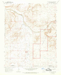
1966 Map of Kin Klizhin Ruins
USGS Topo · Published 1969About this map
Ccnm Kin Klizhin Ruins and the massive masonry of Pañasco Blanco Ruins anchor this high-desert landscape in northwestern New Mexico during the mid-1960s. These ancient Chacoan sites are protected within the boundaries of the Chaco Canyon National Monument, which follows the wide, winding course of the Chaco River. The terrain is defined by dramatic elevation changes where the West Mesa overlooks a complex network of seasonal drainages, including the Ah-shi-sle-pah Wash, Kin Klizhin Wash, and Escavada Wash. Scattered infrastructure such as Padilla Well, Beyale Well, and a Corral indicate the area's continued use for livestock and water access. The map also records the jurisdictional boundary where the landscape crosses from San Juan County into McKinley County, illustrating how modern political lines bisect this ancient cultural corridor.
Find a feature on this map
14 named features on this map. Tap any name to fly to it.
Don’t see what you’re looking for? This feature index may not catch every label — zoom into the map to look around manually.
Map Details
Editions of this 1966 Kin Klizhin Ruins Map
Other maps of this area

1883 · Mt. Taylor
USGS Topo · 1:250,000

1886 · Wingate
USGS Topo · 1:250,000

1886 · Mt. Taylor
USGS Topo · 1:250,000

1889 · Largo
USGS Topo · 1:250,000

1889 · Chaco
USGS Topo · 1:250,000

1892 · Wingate
USGS Topo · 1:250,000

1892 · Chaco
USGS Topo · 1:250,000

1892 · Mt. Taylor
USGS Topo · 1:250,000

1895 · Largo
USGS Topo · 1:250,000

1899 · Mt. Taylor
USGS Topo · 1:250,000