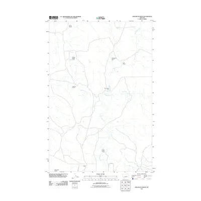
2011 Map of Kincheloe Ranch
USGS Topo · Published 2011About this map
Kincheloe Ranch serves as a central hub in this rangeland landscape of Rosebud County, where water management defines the geography of the high plains. The map reveals an extensive network of drainage and containment, featuring numerous small reservoirs such as L Galt Number 25 Dam, Montana Number 10 Dam, and BS Kincheloe Dam. These structures sit along seasonal watercourses like Rattlesnake Creek and Big Breed Creek, illustrating the vital importance of water storage for ranching operations in this arid environment.
Find a feature on this map
16 named features on this map. Tap any name to fly to it.
Don’t see what you’re looking for? This feature index may not catch every label — zoom into the map to look around manually.
Map Details
Editions of this 2011 Kincheloe Ranch Map
This is the sole edition of this map. No revisions or reprints were ever made.
Other maps of this area

1954 · Forsyth
USGS Topo · 1:250,000

1957 · Forsyth
USGS Topo · 1:250,000

1958 · Forsyth
USGS Topo · 1:250,000

1962 · Melstone NE
USGS Topo · 1:24,000

1962 · Kincheloe Ranch
USGS Topo · 1:24,000

1962 · Mosby SE
USGS Topo · 1:24,000

1962 · Grebe Ranch
USGS Topo · 1:24,000
1963 · Hill Ranch
USGS Topo · 1:24,000

1963 · Mc Williams Springs
USGS Topo · 1:24,000

1963 · Hecker Ranch
USGS Topo · 1:24,000