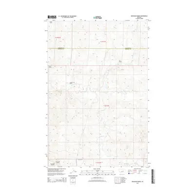
2014 Map of Kincheloe Ranch
USGS Topo · Published 2014About this map
Kincheloe Ranch serves as the primary named site in this expansive portion of the Montana plains, situated where the boundary between Garfield County and Rosebud County bisects the landscape. This 2014 survey captures a topography defined by complex drainage systems and erosion-carved landforms typical of the region. Notable watercourses including Rattlesnake Cr, Big Breed Cr, and Little Breed Cr wind through the township, shaping the surrounding terrain into a series of distinct coulees. To the southwest, the prominent Rattlesnake Buttes rise near Rattlesnake Coulee, providing significant vertical relief in an otherwise undulating prairie. The map details a network of section lines and the singular E Well Rd, reflecting the large-scale ranching operations and public land survey system that organize the modern use of this open country.
Find a feature on this map
16 named features on this map. Tap any name to fly to it.
Don’t see what you’re looking for? This feature index may not catch every label — zoom into the map to look around manually.
Map Details
Editions of this 2014 Kincheloe Ranch Map
This is the sole edition of this map. No revisions or reprints were ever made.
Other maps of this area

1954 · Forsyth
USGS Topo · 1:250,000

1957 · Forsyth
USGS Topo · 1:250,000

1958 · Forsyth
USGS Topo · 1:250,000

1962 · Melstone NE
USGS Topo · 1:24,000

1962 · Kincheloe Ranch
USGS Topo · 1:24,000

1962 · Mosby SE
USGS Topo · 1:24,000

1962 · Grebe Ranch
USGS Topo · 1:24,000
1963 · Hill Ranch
USGS Topo · 1:24,000

1963 · Mc Williams Springs
USGS Topo · 1:24,000

1963 · Hecker Ranch
USGS Topo · 1:24,000