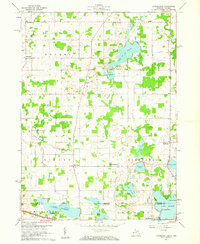
1960 Map of Kinderhook
USGS Topo · Published 1961About this map
Kinderhook and the surrounding townships of Bethel, Ovid, and Gilead define this borderland landscape between Michigan and Indiana. The area is characterized by an intricate network of glacial lakes, including the prominent Lake of the Woods, Pleasant Lake, and Lake Lavine. Small rural settlements like East Gilead and West Kinderhook serve as local hubs, while educational and social foundations are represented by Snow Prairie Sch and School No 6. Along the southern margin, the Indiana Toll Road cuts across Millgrove and Jamestown, signaling the postwar modernization of regional transit. Genealogists will find value in the clear marking of family-named sites such as Knauss Cem and Browns Point on Lake George. The map reflects a mid-century agricultural and recreational economy, where gravel pits operate near quiet lakeshores and small unincorporated hamlets persist alongside new interstate infrastructure.
Find a feature on this map
37 named features on this map. Tap any name to fly to it.
Don’t see what you’re looking for? This feature index may not catch every label — zoom into the map to look around manually.
Map Details
Editions of this 1960 Kinderhook Map
This is the sole edition of this map. No revisions or reprints were ever made.
Other maps of this area

1939 · Angola East
USGS Topo · 1:24,000

1940 · Orland
USGS Topo · 1:24,000

1941 · Orland
USGS Topo · 1:24,000

1941 · Angola West
USGS Topo · 1:24,000

1942 · Angola West
USGS Topo · 1:24,000

1947 · Angola East
USGS Topo · 1:24,000

1953 · Fort Wayne
USGS Topo · 1:250,000

1956 · Fort Wayne
USGS Topo · 1:250,000

1960 · Coldwater West
USGS Topo · 1:24,000

1960 · Coldwater East
USGS Topo · 1:24,000