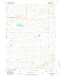
1983 Map of Kindt Reservoir
USGS Topo · Published 1983About this map
Kindt Reservoir sits at the center of this Wyoming high plains landscape, where water management and historic transportation routes define the land use. The historic Overland Trail cuts across the northern half of the quadrangle, tracing a path south of Coal Mine Draw and passing through the Bolten Ranch vicinity. The map documents a rugged drainage network including Little Sage Creek, Miller Creek, and Rasmussen Creek, which provide essential water in this arid ranching and mining environment. Industrial activity is evidenced by a Coal Mine and a second unnamed Mine in the northeast, tucked away in the draws. This survey captures a moment in the late 1970s and early 1980s when traditional ranching at sites like Bolten Ranch existed alongside legacy mining operations and established reservoirs like Sage Creek Reservoir.
Find a feature on this map
14 named features on this map. Tap any name to fly to it.
Don’t see what you’re looking for? This feature index may not catch every label — zoom into the map to look around manually.
Map Details
Editions of this 1983 Kindt Reservoir Map
This is the sole edition of this map. No revisions or reprints were ever made.
Other maps of this area

1893 · Fort Steele
USGS Topo · 1:125,000

1932 · Savery
USGS Topo · 1:96,000

1939 · Saratoga
USGS Topo · 1:125,000

1940 · Savery
USGS Topo · 1:125,000

1954 · Rawlins
USGS Topo · 1:250,000

1955 · Overland Crossing
USGS Topo · 1:24,000

1955 · Savage Ranch
USGS Topo · 1:24,000

1956 · Bolten Ranch
USGS Topo · 1:62,500

1958 · Rawlins
USGS Topo · 1:250,000

1961 · Middlewood Hill
USGS Topo · 1:24,000