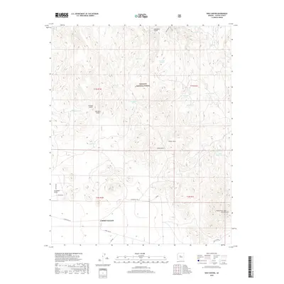
2018 Map of King Canyon
USGS Topo · Published 2018About this map
Chino Valley sits at the southern edge of this high-desert landscape, where the northern reaches of Lonesome Valley meet the rugged drainages of the Prescott National Forest. The terrain is defined by a series of deep canyons and draws, including King Canyon, Gold Basin Canyon, and Muldoon Canyon, which channel seasonal water toward the Verde River in the northeast corner. This modern survey reflects the vital role of water management in the Arizona backcountry, marking numerous livestock tanks such as Robert E Tank, Gold Tank, and Lower Wildcat Tank. These features, alongside family-named landmarks like Munds Draw Saint Matthews Mtn, underscore a history of ranching and land use. Local connectivity is maintained through rural routes like Haystack Rd and E Perkinsville Rd, which traverse the open flats and provide access to the interior forest boundaries.
Find a feature on this map
33 named features on this map. Tap any name to fly to it.
Don’t see what you’re looking for? This feature index may not catch every label — zoom into the map to look around manually.
Map Details
Editions of this 2018 King Canyon Map
This is the sole edition of this map. No revisions or reprints were ever made.
Other maps of this area

1887 · Prescott
USGS Topo · 1:250,000

1892 · Prescott
USGS Topo · 1:250,000

1905 · Jerome
USGS Topo · 1:125,000

1944 · Clarkdale
USGS Topo · 1:48,000

1944 · Mingus Mountain
USGS Topo · 1:62,500

1947 · Mingus Mtn
USGS Topo · 1:62,500

1947 · Paulden
USGS Topo · 1:62,500

1947 · Prescott
USGS Topo · 1:62,500

1948 · Prescott
USGS Topo · 1:62,500
1948 · Clarkdale
USGS Topo · 1:62,500