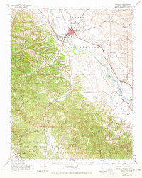
1961 Map of King City
USGS Topo · Published 1968About this map
The Salinas River valley serves as the central artery for this portion of Monterey County, anchoring the agricultural and transportation corridor around King City. The Southern Pacific railroad parallels the river, connecting smaller siding locations like Elsa and Welby to the regional economy. Beyond the irrigated valley floor, the landscape transitions into the steep, canyon-riven terrain of the Oat Hills and the massive Hunter Liggett Military Reservation to the southwest.
Find a feature on this map
63 named features on this map. Tap any name to fly to it.
Don’t see what you’re looking for? This feature index may not catch every label — zoom into the map to look around manually.
Map Details
Editions of this 1961 King City Map
This is the sole edition of this map. No revisions or reprints were ever made.
Other maps of this area

1912 · San Ardo
USGS Topo · 1:31,680

1912 · Metz
USGS Topo · 1:31,680

1915 · Soledad
USGS Topo · 1:62,500

1915 · Priest Valley
USGS Topo · 1:125,000

1919 · King City
USGS Topo · 1:62,500

1919 · Junipero Serra
USGS Topo · 1:62,500

1919 · Bryson
USGS Topo · 1:62,500

1919 · Bradley
USGS Topo · 1:62,500

1921 · Cape San Martin
USGS Topo · 1:62,500

1921 · Metz
USGS Topo · 1:62,500