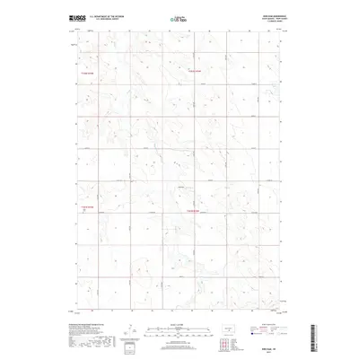
2017 Map of King Dam
USGS Topo · Published 2017About this map
Thunder Cr weaves across this rural landscape of Tripp County, which is defined by its wide section-line road network and occasional water management structures. The northern portion of the map is dominated by the upper reaches of this drainage, while the central and southern areas are punctuated by local reservoirs like King Dam and Covey Dam. This 2017 survey reflects the enduring agricultural character of the region, where the vast majority of the land is organized into a meticulous grid of township and range lines. Along the western edge, the Ideal Cem stands as a focal point for local genealogy and history, situated near Co Rd 6140. The infrastructure is primarily composed of graveled routes such as 318th Ave and 264th St, which facilitate movement through this high plains environment.
Find a feature on this map
21 named features on this map. Tap any name to fly to it.
Don’t see what you’re looking for? This feature index may not catch every label — zoom into the map to look around manually.
Map Details
Editions of this 2017 King Dam Map
This is the sole edition of this map. No revisions or reprints were ever made.
Other maps of this area

1951 · Ideal NW
USGS Topo · 1:24,000

1951 · Ideal NE
USGS Topo · 1:24,000

1952 · Hamill NW
USGS Topo · 1:24,000

1955 · Mitchell
USGS Topo · 1:250,000

1959 · Mitchell
USGS Topo · 1:250,000

1971 · Hamill
USGS Topo · 1:24,000

1971 · Rattlesnake Butte West
USGS Topo · 1:24,000

1982 · King Dam
USGS Topo · 1:25,000

1982 · Winner North
USGS Topo · 1:25,000
1982 · Miller Hill
USGS Topo · 1:25,000