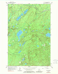
1956 Map of King Lake
USGS Topo · Published 1989About this map
Cloquet Valley State Forest dominates this northern landscape, which was documented during a mid-century field check of the glacial lake country north of Duluth. The terrain is defined by an intricate network of water bodies, including the large expanse of King Lake and the smaller Kookoosh Lake, all connected by winding drainages like Pine Creek. The industrial footprint of the Iron Range is evident in the northern corridor, where the Duluth Missabe and Iron Range railroad tracks cut across the timberland.
Find a feature on this map
33 named features on this map. Tap any name to fly to it.
Don’t see what you’re looking for? This feature index may not catch every label — zoom into the map to look around manually.
Map Details
Editions of this 1956 King Lake Map
3 editions found
Other maps of this area

1953 · Whyte
USGS Topo · 1:62,500

1954 · Barrs Lake
USGS Topo · 1:24,000

1954 · Mc Carthy Creek
USGS Topo · 1:24,000

1954 · Two Harbors
USGS Topo · 1:250,000

1956 · Pequaywan Lake
USGS Topo · 1:24,000

1956 · King Lake
USGS Topo · 1:24,000

1957 · Two Harbors
USGS Topo · 1:250,000

1957 · Two Harbors
USGS Topo · 1:62,500

1957 · Two Harbors
USGS Topo · 1:24,000

1957 · Brimson
USGS Topo · 1:62,500