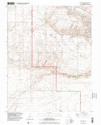
1997 Map of King Mesa
USGS Topo · Published 2002About this map
King Mesa and the surrounding Glen Canyon National Recreation Area dominate this landscape, which is defined by the winding course of the Escalante River. The 1997 photo-inspection reveals a complex network of canyons and plateaus, including Scorpion Canyon and the Ezra Bench Area. The mapping of natural spans is particularly detailed here, documenting the locations of Jacob Hamblin Arch, Coyote Natural Bridge, Stevens Arch, and Sunset Natural Arch.
Find a feature on this map
21 named features on this map. Tap any name to fly to it.
Don’t see what you’re looking for? This feature index may not catch every label — zoom into the map to look around manually.
Map Details
Editions of this 1997 King Mesa Map
This is the sole edition of this map. No revisions or reprints were ever made.
Other maps of this area

1886 · Escalante
USGS Topo · 1:250,000

1886 · Henry Mountains
USGS Topo · 1:250,000

1892 · Henry Mountains
USGS Topo · 1:250,000

1953 · Mt Pennell 3 SW
USGS Topo · 1:24,000

1953 · Circle Cliffs 4 SW
USGS Topo · 1:24,000

1953 · The Rincon
USGS Topo · 1:62,500

1953 · Hall Mesa
USGS Topo · 1:62,500

1953 · Moody Creek
USGS Topo · 1:62,500

1956 · Escalante
USGS Topo · 1:250,000

1960 · Escalante
USGS Topo · 1:250,000