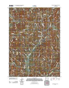
2011 Map of King Mountain
USGS Topo · Published 2011About this map
King Mountain and Quartzmill Peak anchor this Jackson County landscape, where a dense network of timber and access roads crisscrosses the drainage basins of Grave Creek and Pleasant Creek. The map documents a complex system of Bureau of Land Management (BLM) routes, such as BLM 33-5-26 Rd and BLM 34-4-5 Rd, which serve the high ridgelines and steep gulches.
Find a feature on this map
59 named features on this map. Tap any name to fly to it.
Don’t see what you’re looking for? This feature index may not catch every label — zoom into the map to look around manually.
Map Details
Editions of this 2011 King Mountain Map
This is the sole edition of this map. No revisions or reprints were ever made.
Other maps of this area

1904 · Riddle
USGS Topo · 1:125,000

1954 · Days Creek
USGS Topo · 1:62,500

1954 · Glendale
USGS Topo · 1:62,500

1954 · Wimer
USGS Topo · 1:62,500

1954 · Canyonville
USGS Topo · 1:62,500

1955 · Medford
USGS Topo · 1:250,000

1957 · Medford
USGS Topo · 1:250,000

1958 · Medford
USGS Topo · 1:250,000
1983 · Wimer
USGS Topo · 1:24,000
1983 · Skeleton Mtn
USGS Topo · 1:24,000