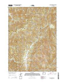
2014 Map of King Mountain
USGS Topo · Published 2014About this map
King Mountain and Quartzmill Peak dominate the high-elevation landscape where the borders of Douglas, Josephine, and Jackson counties converge. This 2014 survey captures a terrain defined by complex hydrography, with numerous water sources like Mud Springs, Onion Springs, and Pease Spring feeding into drainages such as Grave Cr and Quines Cr. The map reveals a dense network of forest and resource management routes, including King Mountain Rd, Quines Creek Rd, and Big Boulder Creek Rd, which provide access to topographical landmarks like Waggoner Gap and Green Mtn. This area's geography is further characterized by deep incisions like French Gulch and Jamison Gulch near the southern boundary, illustrating the traditional drainages that have historically shaped local land use and boundary definitions in this part of Oregon.
Find a feature on this map
95 named features on this map. Tap any name to fly to it.
Don’t see what you’re looking for? This feature index may not catch every label — zoom into the map to look around manually.
Map Details
Editions of this 2014 King Mountain Map
This is the sole edition of this map. No revisions or reprints were ever made.
Other maps of this area

1904 · Riddle
USGS Topo · 1:125,000

1954 · Days Creek
USGS Topo · 1:62,500

1954 · Glendale
USGS Topo · 1:62,500

1954 · Wimer
USGS Topo · 1:62,500

1954 · Canyonville
USGS Topo · 1:62,500

1955 · Medford
USGS Topo · 1:250,000

1957 · Medford
USGS Topo · 1:250,000

1958 · Medford
USGS Topo · 1:250,000
1983 · Wimer
USGS Topo · 1:24,000
1983 · Skeleton Mtn
USGS Topo · 1:24,000