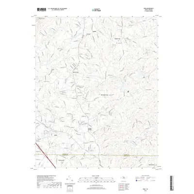
2019 Map of King
USGS Topo · Published 2019About this map
King and its surrounding rural communities occupy the transitional landscape between the Piedmont and the foothills of the Blue Ridge. The terrain is defined by the drainage systems of the E-Prong Little Yadkin River and Town Fork Creek, which have carved numerous small valleys across the southern portion of Stokes County. Settlement patterns follow the ridges and creek beds, connecting established locales such as Mount Olive, Quaker Gap, and Capella. In the northwest, the elevation rises toward Sauratown Mtn, near the recreational area of Camp Hanes and its associated Camp Hanes Lake. The map reveals a dense network of family and community history, documented through numerous burial grounds like the Tillotson Cem and Sizemore Cem, while the southern boundary marks the transition into Forsyth County near Tobaccoville.
Find a feature on this map
210 named features on this map. Tap any name to fly to it.
Don’t see what you’re looking for? This feature index may not catch every label — zoom into the map to look around manually.
Map Details
Editions of this 2019 King Map
This is the sole edition of this map. No revisions or reprints were ever made.
Other maps of this area

1951 · Rural Hall
USGS Topo · 1:24,000

1951 · Walkertown
USGS Topo · 1:24,000

1953 · Winston-Salem
USGS Topo · 1:250,000

1955 · Winston-Salem
USGS Topo · 1:250,000

1962 · Winston-Salem
USGS Topo · 1:250,000

1964 · Hanging Rock
USGS Topo · 1:24,000

1964 · Pinnacle
USGS Topo · 1:24,000

1964 · King
USGS Topo · 1:24,000

1964 · Pilot Mountain
USGS Topo · 1:24,000
1968 · Vienna
USGS Topo · 1:24,000