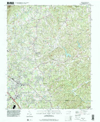
1996 Map of King
USGS Topo · Published 2001About this map
King and Tobaccoville anchor the southern portion of this landscape, marking a transition from the developing residential corridors along the Forsyth and Stokes County line to the more agricultural northern reaches. The terrain is defined by the drainage systems of the Little Yadkin River and Muddy Creek, which carve through the Piedmont toward the northern peaks. Higher elevations are dominated by Sauratown Mtn and the southern edge of Hanging Rock State Park, where the natural gap at Quaker Gap provides a passage through the prominent ridgelines.
Find a feature on this map
38 named features on this map. Tap any name to fly to it.
Don’t see what you’re looking for? This feature index may not catch every label — zoom into the map to look around manually.
Map Details
Editions of this 1996 King Map
This is the sole edition of this map. No revisions or reprints were ever made.
Other maps of this area

1951 · Rural Hall
USGS Topo · 1:24,000

1951 · Walkertown
USGS Topo · 1:24,000

1953 · Winston-Salem
USGS Topo · 1:250,000

1955 · Winston-Salem
USGS Topo · 1:250,000

1962 · Winston-Salem
USGS Topo · 1:250,000

1964 · Hanging Rock
USGS Topo · 1:24,000

1964 · Pinnacle
USGS Topo · 1:24,000

1964 · King
USGS Topo · 1:24,000

1964 · Pilot Mountain
USGS Topo · 1:24,000
1968 · Vienna
USGS Topo · 1:24,000