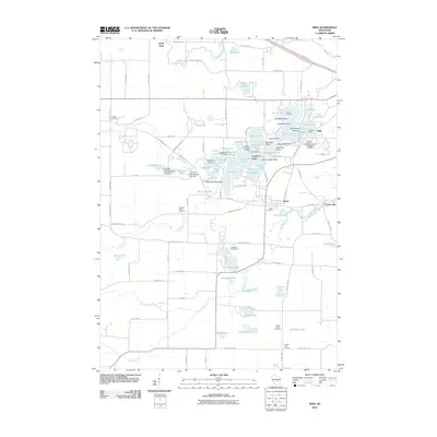
2010 Map of King
USGS Topo · Published 2010About this map
King and its complex network of interconnected glacial lakes define this portion of Waupaca County. The landscape is characterized by numerous small bodies of water, including the densely clustered Chain O' Lakes and larger features like Rainbow Lake and Taylor Lake. The community of King is notably home to the Wisconsin Veterans Memorial Cemetery and Edmunds Dock. To the south, the Crystal River winds toward the small settlements of Rural and Parfreyville. The geography here shows a transition from the water-rich resort and residential areas in the north to the more open agricultural lands surrounding Cobb Town and Crystal Lake Corners. Local history is anchored by sites such as the Badger Cemetery and the Indian Crossing Bridge, which spans the narrow channels connecting the northern lakes. Managed water levels are evident at the Hartman Creek Number One Dam, illustrating the long-standing engineering of this hydrologically active region.
Find a feature on this map
93 named features on this map. Tap any name to fly to it.
Don’t see what you’re looking for? This feature index may not catch every label — zoom into the map to look around manually.
Map Details
Editions of this 2010 King Map
This is the sole edition of this map. No revisions or reprints were ever made.
Other maps of this area

1955 · Green Bay
USGS Topo · 1:250,000

1957 · Amherst
USGS Topo · 1:48,000

1957 · Waupaca
USGS Topo · 1:48,000

1959 · Wautoma
USGS Topo · 1:48,000

1961 · Redgranite
USGS Topo · 1:62,500

1961 · Saxeville
USGS Topo · 1:24,000

1961 · Wild Rose
USGS Topo · 1:24,000
1968 · Wautoma NE
USGS Topo · 1:24,000
1969 · Waupaca
USGS Topo · 1:24,000
1969 · King
USGS Topo · 1:24,000