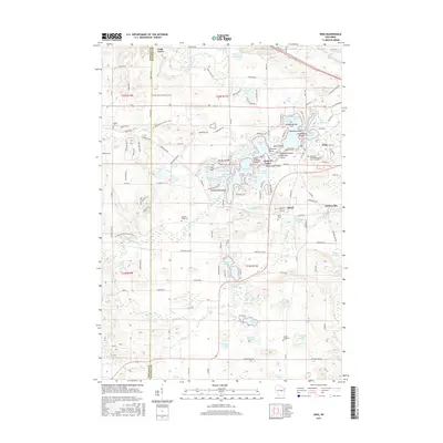
2015 Map of King
USGS Topo · Published 2015About this map
The intricate Chain O' Lakes waterway network dominates this 2015 survey of central Wisconsin, where the village of King and the Wisconsin Veterans Memorial Cem - Central occupy a landscape shaped by glacial activity. The map meticulously details the clustered islands of Onaway Island, Williams Island, and Government Island which dot the waters of Rainbow Lake and Taylor Lake. This region is a complex intersection of small settlements like Rural, Cobb Town, and Parfreyville, linked by historic crossings such as Benedict Bridge and Indian Crossing Bridge.
Find a feature on this map
154 named features on this map. Tap any name to fly to it.
Don’t see what you’re looking for? This feature index may not catch every label — zoom into the map to look around manually.
Map Details
Editions of this 2015 King Map
This is the sole edition of this map. No revisions or reprints were ever made.
Other maps of this area

1955 · Green Bay
USGS Topo · 1:250,000

1957 · Amherst
USGS Topo · 1:48,000

1957 · Waupaca
USGS Topo · 1:48,000

1959 · Wautoma
USGS Topo · 1:48,000

1961 · Redgranite
USGS Topo · 1:62,500

1961 · Saxeville
USGS Topo · 1:24,000

1961 · Wild Rose
USGS Topo · 1:24,000
1968 · Wautoma NE
USGS Topo · 1:24,000
1969 · Waupaca
USGS Topo · 1:24,000
1969 · King
USGS Topo · 1:24,000