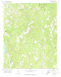
1971 Map of Kings Creek
USGS Topo · Published 1974About this map
Kings Mountain National Military Park and Kings Mountain State Park dominate the northeastern corner of this 1971 study, where the border of Cherokee and York counties runs through the timbered hills. The Southern railroad line cuts diagonally across the landscape, serving the small community of Kings Creek and the village of Smyrna. Industrial activity is evident through numerous claypits scattered along the drainages of Manning Branch and Kings Creek.
Find a feature on this map
39 named features on this map. Tap any name to fly to it.
Don’t see what you’re looking for? This feature index may not catch every label — zoom into the map to look around manually.
Map Details
Editions of this 1971 Kings Creek Map
3 editions found
Other maps of this area

1906 · Kings Mountain
USGS Topo · 1:62,500

1907 · Sharon
USGS Topo · 1:62,500

1908 · Kings Mountain
USGS Topo · 1:62,500

1909 · Gaffney
USGS Topo · 1:62,500

1941 · Spartanburg
USGS Topo · 1:250,000

1953 · Spartanburg
USGS Topo · 1:250,000

1953 · Charlotte
USGS Topo · 1:250,000

1954 · Charlotte
USGS Topo · 1:250,000

1960 · Charlotte
USGS Topo · 1:250,000

1960 · Spartanburg
USGS Topo · 1:250,000