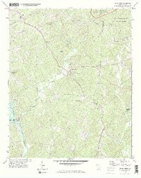
1971 Map of Kings Creek
USGS Topo · Published 1974About this map
Industrial and rural landscapes converge along the Broad River in this early 1970s survey. The southwestern corner is dominated by the Ninetynine Island Dam and its associated Powerplant, marking a significant point of energy production for the region. To the northeast, the terrain shifts into the preserved forest lands of Kings Mountain National Military Park and Kings Mountain State Park, highlighting the intersection of historical preservation and public recreation.
Find a feature on this map
41 named features on this map. Tap any name to fly to it.
Don’t see what you’re looking for? This feature index may not catch every label — zoom into the map to look around manually.
Map Details
Editions of this 1971 Kings Creek Map
3 editions found
Other maps of this area

1906 · Kings Mountain
USGS Topo · 1:62,500

1907 · Sharon
USGS Topo · 1:62,500

1908 · Kings Mountain
USGS Topo · 1:62,500

1909 · Gaffney
USGS Topo · 1:62,500

1941 · Spartanburg
USGS Topo · 1:250,000

1953 · Spartanburg
USGS Topo · 1:250,000

1953 · Charlotte
USGS Topo · 1:250,000

1954 · Charlotte
USGS Topo · 1:250,000

1960 · Charlotte
USGS Topo · 1:250,000

1960 · Spartanburg
USGS Topo · 1:250,000