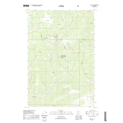
2020 Map of Kings Hill
USGS Topo · Published 2020About this map
The Little Belt Mountains define this high-altitude landscape where the headwaters of numerous creeks diverge across the continental divide. In this 2020 topographic survey, the terrain is marked by prominent summits like Porphyry Peak and Mizpah Peak, providing a detailed look at the drainage basins of Sheep Creek and the various forks of Deadman Creek. The map documents a network of forest access and recreation routes, including Lone Grave Atv and Kings Hill Atv, which connect high-country meadows like Moose Park and Spur Park. A small cluster of development is visible at Forest Green in the southwest, while the northeastern corner shows the settlement of Weatherwax. The convergence of Meagher, Cascade, and Judith Basin county lines at these heights highlights the area's role as a geographic and administrative boundary in central Montana.
Find a feature on this map
46 named features on this map. Tap any name to fly to it.
Don’t see what you’re looking for? This feature index may not catch every label — zoom into the map to look around manually.
Map Details
Editions of this 2020 Kings Hill Map
This is the sole edition of this map. No revisions or reprints were ever made.
Other maps of this area

1886 · Little Belt Mts.
USGS Topo · 1:250,000

1894 · Little Belt Mts.
USGS Topo · 1:250,000

1897 · Little Belt Mts.
USGS Topo · 1:250,000

1898 · Little Belt Mts.
USGS Topo · 1:250,000

1902 · Little Belt Mts.
USGS Topo · 1:250,000

1948 · White Sulphur Springs
USGS Topo · 1:250,000

1958 · White Sulphur Springs
USGS Topo · 1:250,000

1961 · White Sulphur Springs
USGS Topo · 1:250,000
1961 · Kings Hill
USGS Topo · 1:24,000
1961 · Neihart
USGS Topo · 1:24,000