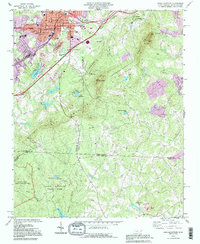
1993 Map of Kings Mountain
USGS Topo · Published 1996About this map
Kings Mountain straddles the state line between North Carolina and South Carolina, serving as a focal point for regional history and conservation in the early 1990s. The landscape is dominated by the prominent ridges of Crowders Mountain and The Pinnacle, with large protected areas including Crowders Mountain State Park and Kings Mountain State Park preserving the Piedmont terrain. The presence of Kings Mountain National Military Park at the southwestern edge highlights the area's Revolutionary War significance, while industrial activity is evidenced by scattered mines and a quarry near the city center. Smaller communities like Mountain View and East Side surround the main town, supported by local institutions such as Boyds Mem Ch and Pisgah Cem. Water features like Lake Mintonia and Sparrow Springs Lake provide drainage across the county lines, while the local infrastructure includes a WT Filtration Plant and several Industrial Waste Ponds.
Find a feature on this map
67 named features on this map. Tap any name to fly to it.
Don’t see what you’re looking for? This feature index may not catch every label — zoom into the map to look around manually.
Map Details
Editions of this 1993 Kings Mountain Map
This is the sole edition of this map. No revisions or reprints were ever made.
Other maps of this area

1906 · Kings Mountain
USGS Topo · 1:62,500

1908 · Kings Mountain
USGS Topo · 1:62,500

1909 · Lincolnton
USGS Topo · 1:62,500

1911 · Lincolnton
USGS Topo · 1:62,500

1914 · Gastonia
USGS Topo · 1:48,000

1916 · Gastonia
USGS Topo · 1:62,500

1947 · Clover
USGS Topo · 1:62,500

1949 · Clover
USGS Topo · 1:62,500

1953 · Charlotte
USGS Topo · 1:250,000

1954 · Charlotte
USGS Topo · 1:250,000