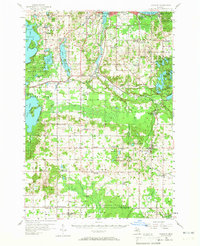
1956 Map of Kingsley
USGS Topo · Published 1965About this map
The Boardman River carves a deep valley through this landscape south of Traverse City Airport, illustrating the glacial topography of Grand Traverse County in the mid-1950s. While Kingsley and Buckley serve as established hubs, the map reveals a rural transition with numerous closed educational sites, including Howard Sch and Canada Sch. These decommissioned schools, along with others like Gray Sch and Potter Sch, indicate a shifting demographic as small country school districts consolidated into larger systems.
Find a feature on this map
104 named features on this map. Tap any name to fly to it.
Don’t see what you’re looking for? This feature index may not catch every label — zoom into the map to look around manually.
Map Details
Editions of this 1956 Kingsley Map
2 editions found
Other maps of this area

1954 · Traverse City
USGS Topo · 1:250,000

1956 · Fife Lake
USGS Topo · 1:62,500

1956 · Kingsley
USGS Topo · 1:62,500

1956 · Mesick
USGS Topo · 1:62,500

1956 · Thompsonville
USGS Topo · 1:62,500

1956 · Cadillac North
USGS Topo · 1:62,500

1957 · Traverse City
USGS Topo · 1:62,500

1957 · Copemish
USGS Topo · 1:62,500

1957 · Maple City
USGS Topo · 1:62,500

1957 · Elk Rapids
USGS Topo · 1:62,500
Featured Places
- Garfield Township, MI
- Garfield Charter Township, Garfield Township
- Traverse City, MI
- East Bay Township, MI
- East Bay Charter Township, East Bay Township