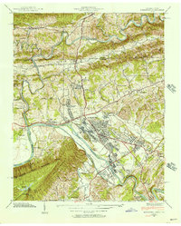
1939 Map of Kingsport
USGS Topo · Published 1956About this map
Kingsport is the industrial and geographic anchor of this 1939 Tennessee Valley Authority survey, situated where the North Fork Holston River and the South Fork Holston River converge. The landscape is defined by the heavy presence of the Southern and Clinchfield railroads, which served the area's growing neighborhoods like Borden Village, Highland Park, and Litz Manor. Beyond the city center, the terrain rises into the Bays Mountains and Walker Ridge, where smaller rural landmarks such as Walnut Chapel and Greenville School persist.
Find a feature on this map
92 named features on this map. Tap any name to fly to it.
Don’t see what you’re looking for? This feature index may not catch every label — zoom into the map to look around manually.
Map Details
Editions of this 1939 Kingsport Map
2 editions found
Other maps of this area

1891 · Roan Mountain
USGS Topo · 1:125,000

1892 · Greeneville
USGS Topo · 1:125,000

1894 · Roan Mountain
USGS Topo · 1:125,000

1894 · Estillville
USGS Topo · 1:125,000

1896 · Greeneville
USGS Topo · 1:125,000

1897 · Bristol
USGS Topo · 1:125,000

1902 · Bristol
USGS Topo · 1:125,000

1904 · Roan Mountain
USGS Topo · 1:125,000

1904 · Greeneville
USGS Topo · 1:125,000

1935 · Hilton
USGS Topo · 1:24,000