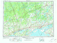
1954 Map of Kingston
USGS Topo · Published 1968About this map
The Kingston waterfront and the upper reaches of the St. Lawrence River define this mid-century cross-border survey. The landscape is dominated by the intricate waterways of eastern Ontario, where the Rideau Canal connects the Rideau River system through Upper Rideau Lake toward Smiths Falls. Along the northern shore of Lake Ontario, industrial and transport hubs like Belleville, Trenton, and the Tyendinaga Ind Res near Deseronto appear alongside the expansive Prince Edward County peninsula.
Find a feature on this map
146 named features on this map. Tap any name to fly to it.
Don’t see what you’re looking for? This feature index may not catch every label — zoom into the map to look around manually.
Map Details
Editions of this 1954 Kingston Map
4 editions found
Other maps of this area

1893 · Sackets Harbor
USGS Topo · 1:62,500

1895 · Sacketts Harbor
USGS Topo · 1:62,500

1895 · Stony Island
USGS Topo · 1:62,500

1895 · Watertown
USGS Topo · 1:62,500

1895 · Cape Vincent
USGS Topo · 1:62,500

1898 · Watertown
USGS Topo · 1:62,500

1900 · Clayton
USGS Topo · 1:62,500

1903 · Grindstone
USGS Topo · 1:62,500

1903 · Clayton
USGS Topo · 1:62,500

1903 · Alexandria Bay
USGS Topo · 1:62,500