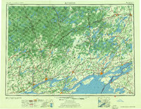
1954 Map of Kingston
USGS Topo · Published 1954About this map
Kingston and the eastern reaches of Lake Ontario serve as the focal point for this mid-century international survey. The landscape is defined by the complex aquatic geography where the lake narrows into the St. Lawrence River, featuring prominent landmasses such as Wolfe Island and Howe Island. On the Canadian side, the Tyendinaga Ind. Res. sits along the Bay of Quinte, while the interior is punctuated by an extensive network of lakes including Rideau Lake and Charleston Lake. This era highlights the established rail corridors of the Canadian National RR and Canadian Pacific RR which linked industrial hubs like Belleville, Trenton, and Smiths Falls. Across the border in New York, the New York Central RR serves the shoreline communities of Cape Vincent and Clayton, illustrating the cross-border transit patterns before modern highway dominance.
Find a feature on this map
299 named features on this map. Tap any name to fly to it.
Don’t see what you’re looking for? This feature index may not catch every label — zoom into the map to look around manually.
Map Details
Editions of this 1954 Kingston Map
4 editions found
Other maps of this area

1893 · Sackets Harbor
USGS Topo · 1:62,500

1895 · Sacketts Harbor
USGS Topo · 1:62,500

1895 · Stony Island
USGS Topo · 1:62,500

1895 · Watertown
USGS Topo · 1:62,500

1895 · Cape Vincent
USGS Topo · 1:62,500

1898 · Watertown
USGS Topo · 1:62,500

1900 · Clayton
USGS Topo · 1:62,500

1903 · Grindstone
USGS Topo · 1:62,500

1903 · Clayton
USGS Topo · 1:62,500

1903 · Alexandria Bay
USGS Topo · 1:62,500