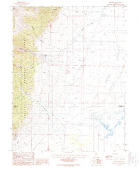
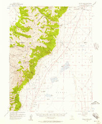
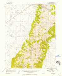
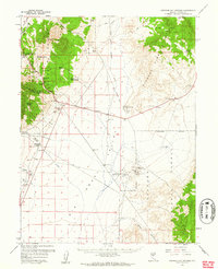
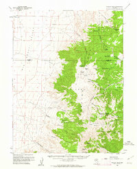
1988 Map of Kingston
USGS Topo · Published 1988About this map
Kingston sits at the foot of the Toiyabe Range, where the steep canyons of the Toiyabe National Forest meet the expansive Big Smoky Valley Depression. In the late 1980s, the landscape reflects a mixture of high-desert recreation and industrial activity, evidenced by the proximity of Kingston Creek to a local Landing Strip and a series of Tailings Ponds. The map captures the transition from the sharp relief of Broad Canyon and Blakeley Canyon to the wide alluvial plains where the Lander Co and Nye Co border crosses through the valley floor. Water management and resource extraction are central themes here, as seen in the presence of a Borrow Pit and the flow of Shoshone Creek toward the sink. This era of the region highlights a quiet desert outpost defined by its proximity to both the forest and the wide-open basin of the Great Desert.
Find a feature on this map
17 named features on this map. Tap any name to fly to it.
Don’t see what you’re looking for? This feature index may not catch every label — zoom into the map to look around manually.
Map Details
Editions of this 1988 Kingston Map
This is the sole edition of this map. No revisions or reprints were ever made.
Other maps of this area

1926 · Roberts Mountains
USGS Topo · 1:250,000

1929 · Roberts Mountains
USGS Topo · 1:250,000

1955 · Millett
USGS Topo · 1:250,000
1956 · Millett Ranch
USGS Topo · 1:62,500
1956 · Austin
USGS Topo · 1:62,500

1959 · Millett
USGS Topo · 1:250,000
1960 · Spencer Hot Springs
USGS Topo · 1:62,500
1960 · Wildcat Peak
USGS Topo · 1:62,500
1978 · Summit Mountain
USGS Topo · 1:100,000
1985 · Smith Creek Valley
USGS Topo · 1:100,000