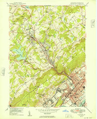
1949 Map of Kingston
USGS Topo · Published 1949About this map
The Susquehanna River defines the southeastern border of this 1940s landscape, where the urban grids of Kingston, Forty Fort, and Edwardsville meet the rising slopes of the Wyoming Valley. This post-war survey documents a transition from the dense industrial and residential riverfront to the upland residential growth of Dallas and Shavertown. The Lehigh Valley RR winds through the hills, connecting these communities to the valley floor. Educational and institutional landmarks are prominent, including Misericordia College in the northwest and Wyoming Seminary in Kingston, alongside the sprawling Huntsville Reservoir. The map captures the complex topography of Larks Mountain and Chestnut Ridge, providing a detailed look at the water infrastructure of the Wilkes-Barre Filtration Plant and various flood basins protecting the developed riverbank.
Find a feature on this map
85 named features on this map. Tap any name to fly to it.
Don’t see what you’re looking for? This feature index may not catch every label — zoom into the map to look around manually.
Map Details
Editions of this 1949 Kingston Map
This is the sole edition of this map. No revisions or reprints were ever made.
Other maps of this area

1891 · Wilkesbarre
USGS Topo · 1:62,500

1891 · Harveys Lake
USGS Topo · 1:62,500

1893 · Harvey Lake
USGS Topo · 1:62,500

1893 · Pittston
USGS Topo · 1:62,500

1894 · Shickshinny
USGS Topo · 1:62,500

1894 · Wilkesbarre
USGS Topo · 1:62,500

1943 · Scranton
USGS Topo · 1:125,000

1946 · Nanticoke
USGS Topo · 1:31,680

1946 · Kingston
USGS Topo · 1:24,000

1946 · Harveys Lake
USGS Topo · 1:24,000