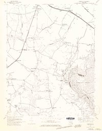
1972 Map of Kingston
USGS Topo · Published 1973About this map
The Pocomoke River and the marshy reaches of Cypress Swamp define the eastern boundary of this Somerset County landscape during the early 1970s. The settlement pattern is characterized by numerous small rural junctions and scattered family-named landmarks such as Smullen and Rehobeth. Transport through the region relies on the Penn Central rail line, which passes through the community of Kingston and continues north toward Westover.
Find a feature on this map
37 named features on this map. Tap any name to fly to it.
Don’t see what you’re looking for? This feature index may not catch every label — zoom into the map to look around manually.
Map Details
Editions of this 1972 Kingston Map
3 editions found
Other maps of this area

1903 · Crisfield
USGS Topo · 1:62,500

1903 · Deal Island
USGS Topo · 1:62,500

1920 · Crisfield
USGS Topo · 1:62,500

1942 · Marion
USGS Topo · 1:24,000

1942 · Monie
USGS Topo · 1:24,000

1942 · Kingston
USGS Topo · 1:24,000

1942 · Princess Anne
USGS Topo · 1:24,000

1942 · Saxis
USGS Topo · 1:24,000

1942 · Dividing Creek
USGS Topo · 1:24,000

1943 · Dividing Creek
USGS Topo · 1:31,680