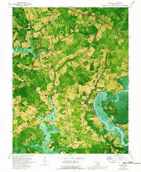
1972 Map of Kingston
USGS Topo · Published 1991About this map
The Pocomoke River winds along the eastern boundary of this Somerset County landscape, where the dense Cypress Swamp meets a grid of tidal creeks and poultry-farming country. In the early 1970s, this region remained a patchwork of woodlots and small agricultural clearings, connected by a network of rural routes such as Shelltown Road and Cornstack Road. The historical settlement of Rehobeth sits near the river bend, marked by notable ruins, while smaller communities like Kingston, Hudson Corner, and Frogeye are scattered across the interior. The presence of numerous small churches, including St Elizabeths Ch and Ebenezer Ch, reflects the deeply rooted social fabric of these Maryland Eastern Shore hamlets. To the north, the Penn Central tracks pass through Westover, a key point in the local rail network that historically served the surrounding truck farms and timber lands.
Find a feature on this map
52 named features on this map. Tap any name to fly to it.
Don’t see what you’re looking for? This feature index may not catch every label — zoom into the map to look around manually.
Map Details
Editions of this 1972 Kingston Map
3 editions found
Other maps of this area

1903 · Crisfield
USGS Topo · 1:62,500

1903 · Deal Island
USGS Topo · 1:62,500

1920 · Crisfield
USGS Topo · 1:62,500

1942 · Marion
USGS Topo · 1:24,000

1942 · Monie
USGS Topo · 1:24,000

1942 · Kingston
USGS Topo · 1:24,000

1942 · Princess Anne
USGS Topo · 1:24,000

1942 · Saxis
USGS Topo · 1:24,000

1942 · Dividing Creek
USGS Topo · 1:24,000

1943 · Dividing Creek
USGS Topo · 1:31,680