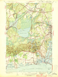
1944 Map of Kingston
USGS Topo · Published 1944About this map
Rhode Island State College stands at the heart of this mid-century landscape, surrounded by the evolving village of Kingston and the academic grounds. To the west, the expansive Great Swamp contains the Great Swamp Fight Site, marking a significant point of historical interest amidst the dense wetlands and the New York New Haven and Hartford RR corridor. The geography transitions from the upland heights of Tefft Hill and Mt Pleasant down to the coastal ponds and salt marshes bordering Block Island Sound.
Find a feature on this map
120 named features on this map. Tap any name to fly to it.
Don’t see what you’re looking for? This feature index may not catch every label — zoom into the map to look around manually.
Map Details
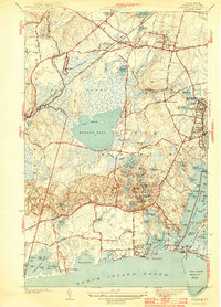
Editions of this 1944 Kingston Map
2 editions found
Other maps of this area

1889 · Charlestown
USGS Topo · 1:62,500

1889 · Newport
USGS Topo · 1:62,500

1890 · Narragansett Bay
USGS Topo · 1:62,500

1890 · Kent
USGS Topo · 1:62,500

1892 · Narragansett Bay
USGS Topo · 1:62,500

1894 · Kent
USGS Topo · 1:62,500

1894 · Newport
USGS Topo · 1:62,500

1904 · Newport
USGS Topo · 1:62,500

1919 · Charlestown
USGS Topo · 1:62,500

1919 · Narragansett Bay
USGS Topo · 1:62,500