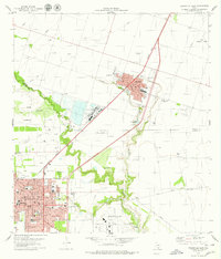
1979 Map of Kingsville East
USGS Topo · Published 1979About this map
The agricultural and industrial character of the coastal bend in the late 1970s is captured here, centered on the growing communities of Bishop and Kingsville. The landscape is a functional mix of vast Oil Fields, chemical production, and military operations at the Kingsville Naval Air Station. In the residential core of Kingsville, local civic life is documented through institutional landmarks such as the Courthouse, Hospital, and numerous neighborhood schools including Lamar Sch and St Gertrudes Sch. The Missouri Pacific railroad serves as the primary transport corridor, paralleling the boundary between Nueces and Kleberg counties. Natural drainage follows the meandering paths of Carreta Creek and San Fernando Creek, which break up the geometric precision of the surrounding oil and gas operations.
Find a feature on this map
28 named features on this map. Tap any name to fly to it.
Don’t see what you’re looking for? This feature index may not catch every label — zoom into the map to look around manually.
Map Details
Editions of this 1979 Kingsville East Map
This is the sole edition of this map. No revisions or reprints were ever made.
Other maps of this area

1924 · Petronilla
USGS Topo · 1:62,500

1928 · Sarita
USGS Topo · 1:125,000

1950 · Corpus Christi
USGS Topo · 1:250,000

1952 · Riviera Beach NW
USGS Topo · 1:24,000

1952 · Riviera Beach
USGS Topo · 1:62,500

1954 · Kingsville
USGS Topo · 1:62,500

1954 · Petronila
USGS Topo · 1:62,500

1954 · Riviera
USGS Topo · 1:62,500

1956 · Corpus Christi
USGS Topo · 1:250,000

1960 · Corpus Christi
USGS Topo · 1:250,000