
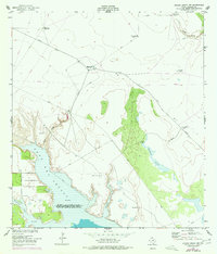
1952 Map of Riviera Beach NW
USGS Topo · Published 1953About this map
Cayo Del Grullo and its shoreline of sand and mud dominate this coastal landscape of Kleberg County in the early 1950s. The map illustrates a ranching and military environment where survival depends on managed water sources. The U S Naval Reservation (Outlying Field 52) occupies the western shore, while the interior is crisscrossed by an extensive network of fences and private ranch roads.
Find a feature on this map
20 named features on this map. Tap any name to fly to it.
Don’t see what you’re looking for? This feature index may not catch every label — zoom into the map to look around manually.
Map Details
Editions of this 1952 Riviera Beach NW Map
2 editions found
Other maps of this area

1924 · Petronilla
USGS Topo · 1:62,500

1928 · Sarita
USGS Topo · 1:125,000

1950 · Corpus Christi
USGS Topo · 1:250,000

1951 · Kleberg Point
USGS Topo · 1:24,000

1951 · Riviera Beach NE
USGS Topo · 1:24,000

1952 · Riviera Beach
USGS Topo · 1:24,000

1952 · Riviera Beach
USGS Topo · 1:62,500

1954 · Kingsville
USGS Topo · 1:62,500

1954 · Petronila
USGS Topo · 1:62,500

1954 · Riviera
USGS Topo · 1:62,500