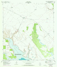
1952 Map of Riviera Beach NW
USGS Topo · Published 1977About this map
The coastal ranchlands of South Texas are defined here by a network of essential water sources and the shifting shoreline of Cayo Del Grullo. This landscape, characterized by the 1952 field check and 1975 revisions, shows a reliance on deep-well infrastructure such as Telephone Well and Mesquite Well to sustain life and industry in an arid environment. The map captures a transition between the wilder terrain of Madero Lake and the organized footprint of the U S Naval Reservation along the western edge of the inlet. Tributaries like Tunas Creek and Pinto Creek cut through the sandy plains, while the tidal flats of Sand and Mud indicate the complex hydrology where meteorological conditions frequently shift the water stages. This record serves as a precise document of property boundaries and remote landmarks in Kleberg County before modern development altered the rural ranching character.
Find a feature on this map
18 named features on this map. Tap any name to fly to it.
Don’t see what you’re looking for? This feature index may not catch every label — zoom into the map to look around manually.
Map Details
Editions of this 1952 Riviera Beach NW Map
2 editions found
Other maps of this area

1924 · Petronilla
USGS Topo · 1:62,500

1928 · Sarita
USGS Topo · 1:125,000

1950 · Corpus Christi
USGS Topo · 1:250,000

1951 · Kleberg Point
USGS Topo · 1:24,000

1951 · Riviera Beach NE
USGS Topo · 1:24,000

1952 · Riviera Beach
USGS Topo · 1:24,000

1952 · Riviera Beach NW
USGS Topo · 1:24,000

1952 · Riviera Beach
USGS Topo · 1:62,500

1954 · Kingsville
USGS Topo · 1:62,500

1954 · Petronila
USGS Topo · 1:62,500