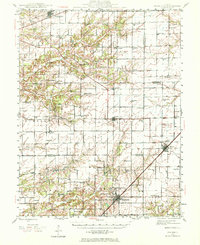
1945 Map of Kinmundy
USGS Topo · Published 1972About this map
Kinmundy and Farina anchor the southern portion of this mid-century landscape where Marion and Fayette counties meet. The area is defined by a dense grid of rural education and worship, featuring numerous country schoolhouses such as Brush College School, German Reformed School, and La Grove School. Transport corridors are prominent, with the Illinois Central, Pennsylvania, and Chicago and Eastern Illinois railroads intersecting the region, facilitating the movement of goods from agricultural outposts like St Peter and Brownstown.
Find a feature on this map
71 named features on this map. Tap any name to fly to it.
Don’t see what you’re looking for? This feature index may not catch every label — zoom into the map to look around manually.
Map Details
Editions of this 1945 Kinmundy Map
2 editions found
Other maps of this area

1914 · Centralia
USGS Topo · 1:62,500

1934 · Salem
USGS Topo · 1:62,500

1935 · Centralia
USGS Topo · 1:62,500

1938 · Salem
USGS Topo · 1:62,500

1941 · St. Elmo
USGS Topo · 1:62,500

1944 · Ramsey
USGS Topo · 1:62,500

1945 · St. Elmo
USGS Topo · 1:62,500

1945 · Kinmundy
USGS Topo · 1:62,500

1945 · Vandalia
USGS Topo · 1:62,500

1946 · Ramsey
USGS Topo · 1:62,500