1972 Map of Kinsley SW
USGS Topo · Published 1974About this map
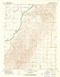
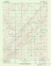
Arkansas River hydrology and early land divisions define this portion of Edwards County during the early 1970s. The landscape is marked by the significant Old Indian Treaty Boundary, which cuts across the southern section of the map, providing a glimpse into the historical surveying and settlement patterns of the Kansas plains. To the north, the town of Kinsley sits near the confluence of Coon Creek and the river, served by the extensive tracks of the Atchison Topeka and Santa Fe Railroad. The terrain transitions into the sand hills of North Brown and South Brown, where the isolated Chapel Ranch stands as a notable landmark in an otherwise sparsely populated expanse of grazing land and intermittent wells.
Find a feature on this map
8 named features on this map. Tap any name to fly to it.
Don’t see what you’re looking for? This feature index may not catch every label — zoom into the map to look around manually.
Map Details
Editions of this 1972 Kinsley SW Map
2 editions found
Other maps of this area

1889 · Kinsley
USGS Topo · 1:125,000

1892 · Kinsley
USGS Topo · 1:125,000

1892 · Spearville
USGS Topo · 1:125,000

1894 · Spearville
USGS Topo · 1:125,000

1894 · Kinsley
USGS Topo · 1:125,000

1955 · Pratt
USGS Topo · 1:250,000

1959 · Pratt
USGS Topo · 1:250,000
1969 · Bucklin NE
USGS Topo · 1:24,000
1969 · Greensburg NW
USGS Topo · 1:24,000
1969 · Greensburg NE
USGS Topo · 1:24,000